
UI for WinForms
WinForms Map
- The Telerik UI for WinForms Map control uses a provider of imagery data in order to visualize a map.
- Part of the Telerik UI for WinForms library along with 160+ professionally-designed UI controls.
- Includes support, documentation, demos, virtual classrooms, Visual Studio Extensions and more!

-
Vector Maps and Custom Shape Data
If you have ESRI shapefiles, KML files or data stored in SQL Geospatial format, RadMap will visualize these for you, together with any additional data these formats may provide.
-
Search, Route and Elevation Services
Aid your users with Bing Search, Route and Elevation services, so they can find an address, calculate different types of routes or see the elevation at certain location or area. The routing service allows navigation and route planning with ability to position lines/curves with locations exceeding the longitude limits [-180;180]
-(1)-(1)-(1)-(1)-(1)-(1)-(1).png?sfvrsn=abbd8732_6)
-
Great End User Experience
Fast and fluid pan and zoom, map wraparound and flawless animation are just some of the features that provide a great user experience for end users.
-
All the UI Elements You Might Need
Built-in elements include pins, callouts, routes, air routes, labels and paths. On top of that, the map UI will also present a mini map, search box, legend, navigation bar and scale indicator.
.png?sfvrsn=d8f66b4d_6)
-
Layers
RadMap allows usage of as many layers as you need, and in each layer you can store different visual elements. This allows you to have a layer with pins, another one with labels, paths, etc.
-(1)-(1)-(1)-(1)-(1).png?sfvrsn=a35c8764_6)
-
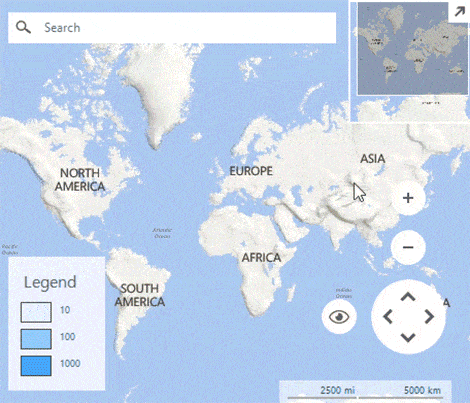
Colorization
When a shape file is displayed, you can use three colorization strategies to colorize the shapes: graph colorization, choropleth colorization and property colorization.
-(1)-(1)-(1)-(1)-(1).png?sfvrsn=e1db9c8f_6)
-
Clusterization
RadMap supports clusterization with different grouping strategies for its layers’ elements. This feature is extremely useful when dealing with large collections with items located close to each other.
-(1)-(1).png?sfvrsn=375863c_6)
-
Raster Map Providers
RadMap has built-in support for Bing and OpenStreetMaps providers, as well as a provider to display locally stored tiles. The control allows you to use your own implementation of any other service.
Bing Maps™ is a web service offered by Microsoft which provides road, earth and hybrid map types.
OpenStreetMap is another popular format and tiles can be accessed either via their official website or from the public image tile service.
-(1)-(1)-(1)-(1)-(1)-(1).png?sfvrsn=7c0a7d92_6)
