Implement Geocoding with the Azure Maps Services
Environment
| Product Version | 2025.1.211 |
| Product | RadMap for WPF |
Description
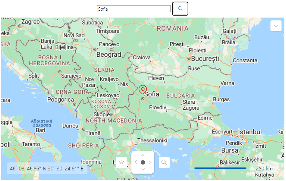
Implementing geocoding (searching) functionality using the Azure Maps services.
Solution
To achieve geocoding functionality using the Azure Maps services, you can create a new helper class. It will create a URL request for the Microsoft's geocoding API and use the response to center the RadMap control. In order to receive a valid response from the geocoding API, you will need to pass a valid location and subscription key to the request URL string.
Implementing a helper class for retrieving the searched location
    internal class AzureGeocodingHelper
    {
        private static HttpClient httpClient = new HttpClient();

        internal async static Task<Location> GetGeoCode(string location)
        {
            //Modify this URL to match your Azure Mapss subscription key and location
            var requestUrl = $"https://atlas.microsoft.com/geocode?api-version=2025-01-01&query={location}&subscription-key={MyAzureMapsSubscriptionKey}";

            var response = await httpClient.GetAsync(requestUrl);
            response.EnsureSuccessStatusCode();

            var jsonContent = await response.Content.ReadAsStringAsync();
            var options = new JsonSerializerOptions
            {
                PropertyNamingPolicy = JsonNamingPolicy.CamelCase,
                PropertyNameCaseInsensitive = true
            };

            var featureCollection = JsonSerializer.Deserialize<FeatureCollection>(jsonContent, options);

            var firstCoordinates = featureCollection.Features.First().Geometry.Coordinates;
            return new Location(firstCoordinates[1], firstCoordinates[0]);
        }
    }

    public class FeatureCollection
    {
        public List<Feature> Features { get; set; }
    }

    public class Feature
    {
        public Geometry Geometry { get; set; }
    }

    public class Geometry
    {
        public List<double> Coordinates { get; set; }
}Additionally, you can follow the next example, which showcases how to utilize the created AzureGeocodingHelper class and its GetGeoCode method.
Defining the RadMap and the UI elements for the geocoding logic
    <Grid>
        <Grid.Resources>
            <ResourceDictionary Source="/Telerik.Windows.Controls;component/Themes/FontResources.xaml"/>
        </Grid.Resources>
        <Grid.RowDefinitions>
            <RowDefinition Height="Auto"/>
            <RowDefinition Height="*"/>
        </Grid.RowDefinitions>
        <StackPanel Orientation="Horizontal" Margin="5" HorizontalAlignment="Center">
            <TextBox x:Name="textBoxSearchAddress" VerticalAlignment="Center" Width="200"/>
            <telerik:RadButton Click="RadButton_Click" VerticalAlignment="Center" Margin="4 0 0 0">
                <telerik:RadButton.Content>
                    <telerik:RadGlyph Glyph="{StaticResource GlyphZoom}"/>
                </telerik:RadButton.Content>
            </telerik:RadButton>
        </StackPanel>
        <telerik:RadMap x:Name="map" Grid.Row="1">
            <telerik:RadMap.Provider>
                <telerik:AzureMapProvider SubscriptionKey="Your Subscription Key"/>
            </telerik:RadMap.Provider>
            <telerik:VisualizationLayer x:Name="visualizationLayer"/>
        </telerik:RadMap>
    </Grid>
Utilizing the AzureGeocodingHelper class's GetGeoCode method
    private async void RadButton_Click(object sender, RoutedEventArgs e)
    {
        try
        {
            Location location = await AzureGeocodingHelper.GetGeoCode(this.textBoxSearchAddress.Text);

            this.visualizationLayer.Items.Clear();
            this.visualizationLayer.Items.Add(location);
            this.map.Center = location;
        }
        catch (Exception exception)
        {
            MessageBox.Show("Please, enter a another location");
        }
}RadMap with AzureMapProvider and geocoding functionality
For a more in-depth example of an Azure Maps services geocoding, check the Geocoding demo from our Demos application.